


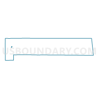
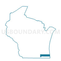
ROCHESTER - T 1 Voting District, Racine County, Wisconsin
About
Outline

Summary
| Unique Area Identifier | 696381 |
| Name | ROCHESTER - T 1 Voting District |
| County | Racine County |
| State | Wisconsin |
| Area (square miles) | 0.23 |
| Land Area (square miles) | 0.21 |
| Water Area (square miles) | 0.03 |
| % of Land Area | 89.08 |
| % of Water Area | 10.92 |
| Latitude of the Internal Point | 42.75384920 |
| Longtitude of the Internal Point | -88.21289410 |
Maps

Graphs
Select a template below for downloading or customizing gragh for ROCHESTER - T 1 Voting District, Racine County, Wisconsin


Neighbors
Neighoring Voting District (by Name) Neighboring Voting District on the Map
- ROCHESTER - T 2 Voting District, Racine County, WI
- Rochester - V 2 Voting District, Racine County, WI
- Waterford - V 6 Voting District, Racine County, WI
- Waterford - V 7 Voting District, Racine County, WI